Heavy snow and rain moved through Utah on Tuesday, Nov. 17, according to a report published that day. Areal flood alerts were issued for several locations in Washington county earlier Tuesday, while heavy snow occurred in areas including Brian Head and the Tushars.
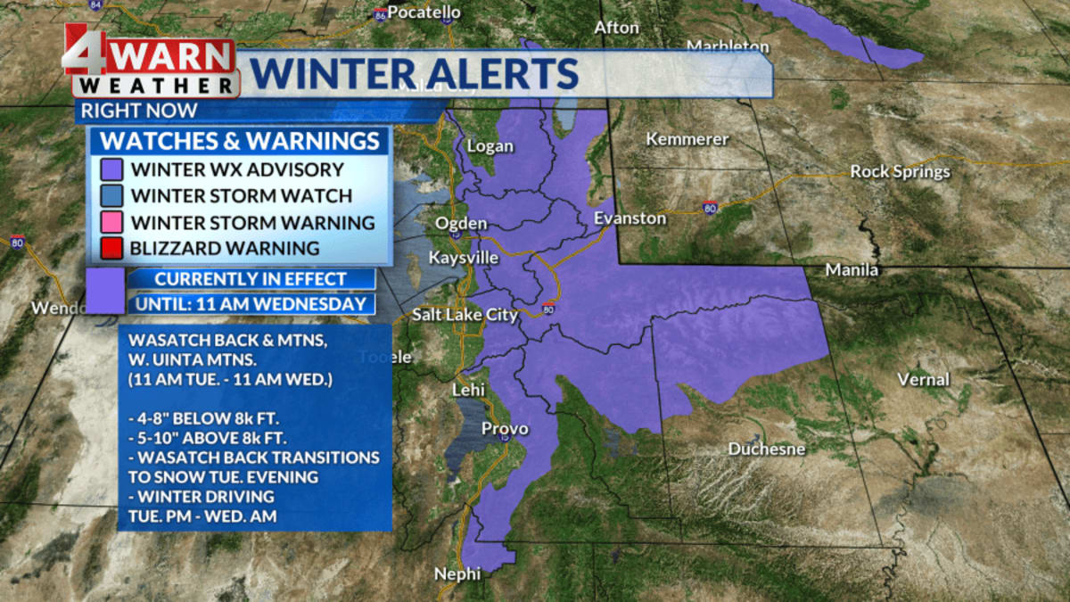
As a cold front moved through Tuesday afternoon, snow levels were expected to drop quickly to some northern valley locations on Tuesday evening. A band of wrap around precipitation through northern Utah could provide a burst of snow to lower elevations, potentially coating grassy and elevated surfaces. The Benches and areas toward the Mountain Valleys across the Wasatch Back were expected to pick up between 1-4 inches of snow Tuesday evening. Additionally, the Wasatch Mountains and Western Uintas were expected to see between 4-10 inches of snow above 8,000 feet.
A Winter Weather Advisory remains in effect for the Wasatch Mountains, Western Uintas, and the Wasatch Back—including Park City and the Heber Valley—through midday Wednesday. This weather may create wintry travel conditions for Tuesday evening and Wednesday morning commutes. Wednesday is expected to bring a brief break between storm systems with a mix of clouds and sunshine and cool temperatures. Highs are expected to reach the upper 40s to near 50 degrees across the Wasatch Front, while southwest Utah may see highs in the mid 50s.
A new storm system is scheduled to arrive Thursday, initially bringing scattered rain and snow to valleys during the day. This slower moving system is expected to increase precipitation coverage throughout Thursday night into Friday morning, potentially bringing snow to valley floors. Significant snow is expected in the mountains this weekend, with some locations potentially measuring snow by the feet by Saturday morning. While Saturday may start with lingering snow showers in northern Utah, a ridge of high pressure is expected to provide drier conditions for most of Sunday.
Weather patterns may become active again starting Sunday night and continuing into early next week.