THE WIRE · UPDATED 2:13 PM MST No story is too small.
Multi-SourceStatewide

Flood Warning Issued for San Juan River Through Thursday

Utah.News 4 sources cited 2 primary Primary: apps.usgs.gov Details

How this story was published

Published automatically from 4 public sources cited; not yet reviewed by the desk. Tell us if something is wrong ↗

Primary source

apps.usgs.gov — an official government, school or university source.

The sources this story cites are listed under Sources used at the end of this story. Questions or a correction: corrections@utah.news.

Official source · AI-written This story comes from an official government or institutional source. How it was made ↓
A close-up view of turbulent, muddy brown river water rushing against a red sandstone bank under a heavy, overcast sky.
AI illustration
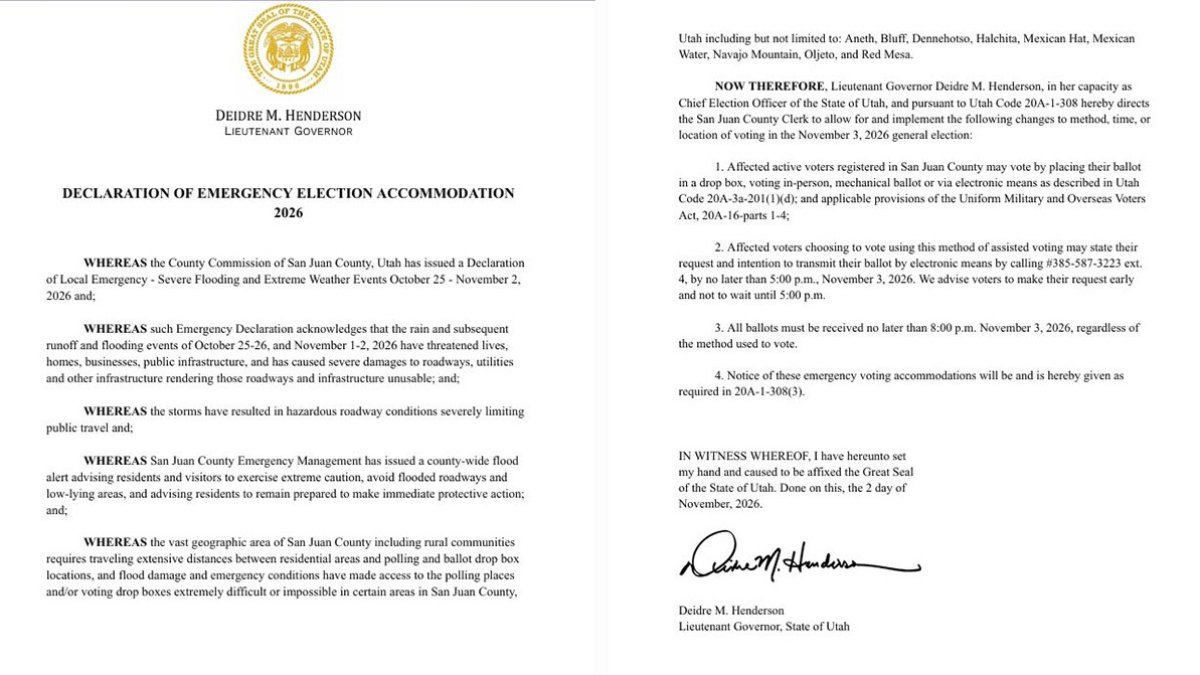
A flood warning remains in effect for the San Juan River through Thursday afternoon, with officials warning that river levels are expected to rise and crest near 23.5 feet. The surge follows unprecedented rainfall in the Four Corners region that previously caused significant flooding in Bluff and surrounding communities.

Key takeaways

  • A flood warning is in effect for the San Juan River until 5:15 p.m. Thursday.
  • The river has already exceeded flood stage at Bluff, with a stage of 23.7 feet reported Tuesday morning.
  • A secondary crest near 23.5 feet is expected early Thursday morning.
  • The flooding follows unprecedented precipitation in the Four Corners region during the week of October 19.
  • Officials warn against driving through flooded roads and advise checking official resources for route closures.

The National Weather Service issued a flood warning Tuesday for the San Juan River, warning that water levels are expected to rise and crest near 23.5 feet by Thursday morning. The warning, which remains in effect until 5:15 p.m. Thursday, follows a significant flood event during the week of October 19 that damaged structures in Bluff and surrounding San Juan County communities.

Rising River Levels and Crest Projections

According to the National Weather Service, the San Juan River has already exceeded flood stage at Bluff, with a stream gauge reporting a stage of 23.7 feet at 8:13 a.m. Tuesday. The agency expects a prolonged period of high water, with a secondary crest projected near 23.5 feet early Thursday morning before the river falls below flood stage.

Impacted Areas and Upstream Flooding

The current flooding is driven by excess runoff from rainfall that occurred on Sunday. The National Weather Service reported that floodwaters are expected to inundate low-lying areas along the river from Bluff to the terminus at Lake Powell. Upstream impacts have already been noted, with flooding reported near Farmington, New Mexico, leading to expectations that floodwaters would reach the Four Corners on Wednesday evening and Bluff early Thursday morning.

Recent Flooding and Evacuations

The current weather emergency follows a historic flood event during the week of October 19, when unprecedented precipitation across the Four Corners and San Juan County caused significant damage. While parts of Bluff were evacuated on Sunday night, the Town of Bluff stated that an evacuation order was lifted early Monday morning.

Community Recovery and Business Status

The Town of Bluff, in a joint statement with San Juan County and Business Owners of Bluff, noted that while the floods damaged and destroyed structures, coordinated efforts by first responders and volunteers kept residents safe. Most Bluff businesses remained untouched by the waters and are open to visitors.

Safety and Travel Guidance

Local officials are urging residents and travelers to exercise extreme caution. The National Weather Service advises motorists to "turn around, don't drown" when encountering flooded roads, noting that most flood deaths occur in vehicles. Travelers are also encouraged to verify road and weather conditions via the Utah Department of Transportation before entering the region.

Sources used (4)

  • bluffutah.org.orgBluff Flood Recovery Information | Bluff, Utah
  • apps.usgs.govOfficialHIVIS
  • forecast.weather.govOfficialWWA Summary by Location for 37.45N 110.04W with UTZ029/UTC037/UTZ491 emphasis Flood Watch
  • kutv.comWebEmergency orders lift for Bluff residents after Cottonwood Wash floods from heavy rain

How this story was made

Corroborated by 4 independent sources

4 sources cited — counted as distinct source domains, listed below.

apps.usgs.govbluffutah.orgforecast.weather.govkutv.com

4 sources gathered

Coverage collected from the outlets listed above. · November 3, 2026

Written by AI

Utah News AI (on-device model) · drawing on 4 outlets · November 3, 2026

Quality checks

Passed editorial quality review (87/100)

Published

14 min ago · November 3, 2026

This story was written by AI from the public sources listed above and passed automated quality review before publishing.

Article details

CategoryMulti-Source
ToneNeutral
ProductionAI Generated
Report a problem with this story
What's off? Pick any that fit, or just write below.

Every report is read and checked against the story's sources. Your email, if you give one, is used only to contact you about this message and is never shown publicly. Please keep other personal details out of the text. Privacy