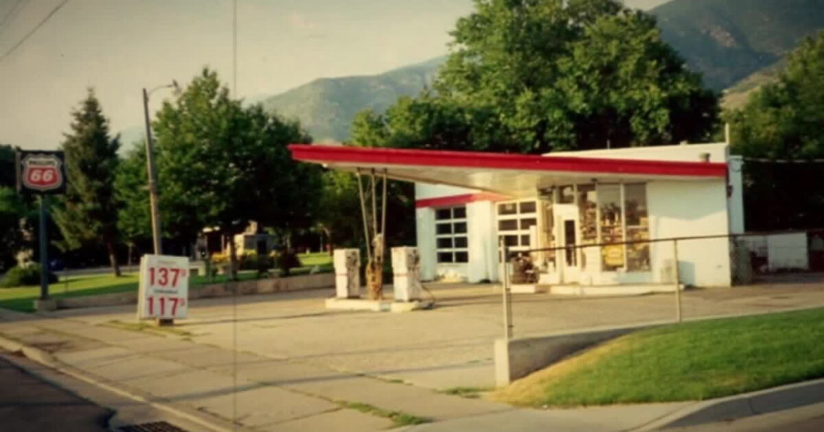
The future of Ron's Phillips 66 Service Station in Centerville remains uncertain as the community weighs the preservation of the mid-century modern landmark against potential development. The historic site, located at 278 North Main Street, was added to the National Register of Historic Places for its architectural significance, a status that has sparked local interest in maintaining the building's original character.
Historic Architectural Significance
The service station, a notable example of mid-century modern nonresidential architecture, holds a significant place in the region's history. According to the National Register of Historic Places, the building's architectural significance is tied to the period between 1960 and 1967. The structure was designed using Phillips Petroleum Company standard plans, with architectural influence attributed to Clarence Reinhardt and other designers including Tom Randall, Bob Trump, Gene Ford, and Therice Duncan.
Regulatory Framework for Development
As the community considers the site's future, the Centerville Zoning Code serves as the primary regulatory framework for any land use changes. The code, which is part of the Centerville Municipal Code under Title 12, is designed to protect public health, safety, and welfare while promoting the prosperity and aesthetics of the city and its inhabitants. The code also aims to protect the city tax base and preserve property values through structured development standards.
Zoning and Land Use Standards
The Centerville Zoning Code is organized into several categories, including base zones, special purpose zones, and overlay zones. Base zones govern land uses in agricultural, residential, public facility, commercial, and industrial districts. Special purpose and overlay zones are utilized to address specific circumstances or geographic areas that may traverse multiple base zones. Any development at the Phillips 66 site would need to align with these established municipal regulations to ensure conformity with city planning.
City Administrative Procedures
The complexity of land use in Centerville is managed through a system of administrative and enforcement provisions. These provisions, found within the Centerville Municipal Code, outline the powers and duties of decision-making bodies and officials. They also establish the procedures for considering land use applications and provide remedies for addressing nonconforming circumstances. The city maintains that these regulations are essential for managing urban and non-urban development and ensuring economic efficiency in governmental expenditures.
The Role of Property Records
Maintaining accurate property records is a fundamental part of the local government's role in managing such historic sites. The Davis County Recorder's Office, which has been safeguarding public land and property records since 1850, provides the official documentation required to track ownership and property details. These records, which include deeds, mortgages, and plats, ensure transparency and security for residents and landowners throughout the county.
Modern Recordkeeping Services
The Davis County Recorder's Office utilizes modern technology to manage these historical documents, offering services such as Property Search and Property Watch. Through these tools, property owners can receive notifications whenever documents are recorded against their title. This system allows for the continuous monitoring of property activity, which is vital for maintaining the integrity of land ownership and legal claims within the community.
Preservation vs. Development
As the debate over the service station continues, the intersection of historic preservation and modern zoning remains a central focus for Centerville. The community's desire to preserve the mid-century modern aesthetic of the Phillips 66 station must be balanced against the city's regulatory requirements for land use and development as outlined in the Centerville Municipal Code.