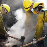
The Stookey Fire, a wildfire caused by natural forces, expanded to 10,337 acres on Bureau of Land Management lands west of Vernon in Tooele County. The incident, located seven miles west of Vernon, was managed by the Salt Lake Field Office and involved 311 personnel as of July 19, 2026.
Fire behavior was described as moderate, with instances of single tree torching and smoldering. The fire burned through six-foot chaparral and brush. At the time of the latest update, containment stood at 40%, with an estimated containment date set for July 23, 2026.
Incident commanders Brian Kitchen and Shawn Krajewski led the response. Planned actions included establishing new control lines on the east and west sides of the Onaqui Range using dozer lines and existing road systems. Officials stated they aimed to prevent the fire from crossing Pony Express Road.
Weather forecasts indicated a potential for fire growth toward the north and northeast due to wind and topography alignment. Such growth threatened the Highway 36 corridor, private property, and the communities of Clover Valley and Rush Valley. The fire footprint also posed a threat to the United States Army Depot Tooele within a two-mile radius, as well as sensitive species habitats and grazing allotments.
A monsoon surge brought the threat of showers and thunderstorms to the region. While monsoonal moisture provided some relief, officials noted hazards including lightning, heavy rain, and potential flash flooding, particularly for the Tuesday and Wednesday following the July 19 update.
Suppression repair efforts were scheduled to begin on areas within containment lines that received approval per the repair plan. While minimal fire growth was expected in the 48 to 72-hour window following the report, smoke dispersal remained a concern for nearby communities.