Flash Flood WarningFlash Flood Warning
UTC053-120315-
/O.EXT.KSLC.FF.W.0142.000000T0000Z-261012T0315Z/
/00000.0.ER.000000T0000Z.000000T0000Z.000000T0000Z.OO/
BULLETIN - EAS ACTIVATION REQUESTED
Flash Flood Warning
National Weather Service Salt Lake City UT
604 PM MDT Sun Oct 11 2026
The National Weather Service in Salt Lake City has extended the
* Flash Flood Warning for...
The Forsyth burn scar in...
Central Washington County in southwestern Utah...
* Until 915 PM MDT.
* At 604 PM MDT, Emergency management reported heavy rain over the
Forsyth Burn Scar and flooding in Pine Valley. Additionally, river
gauges remain high along the Santa Clara River above Baker
Reservoir. Between 1.50 and 3 inches of rain have fallen. Flash
flooding is ongoing. Excessive rainfall over the burn scar will
result in debris flow. The debris flow can consist of rock, mud,
vegetation and other loose materials.
HAZARD...Life threatening flash flooding. Heavy rain producing
flash flooding in and around the Forsyth Burn Scar.
SOURCE...Emergency management reported.
IMPACT...Life threatening flash flooding of areas in and around the
Forsyth Burn Scar.
* Some locations that will experience flash flooding include...
Pine Valley.
This includes Utah Route 18 between mile markers 26 and 27.
PRECAUTIONARY/PREPAREDNESS ACTIONS...
This is a life threatening situation. Heavy rainfall will cause
extensive and severe flash flooding of creeks...streams...and ditches
in the Forsyth Burn Scar. Severe debris flows can also be anticipated
across roads. Roads and driveways may be washed away in places. If
you encounter flood waters...climb to safety.
Be aware of your surroundings and do not drive on flooded roads.
Flooding is occurring or is imminent. It is important to know where
you are relative to streams, rivers, or creeks which can become
killers in heavy rains. Campers and hikers should avoid streams or
creeks.
&&
LAT...LON 3744 11331 3751 11336 3748 11350 3743 11364
3731 11363 3726 11351 3727 11341 3738 11329
FLASH FLOOD...OBSERVED
FLASH FLOOD DAMAGE THREAT...CONSIDERABLE
$$
JACFlash Flood Warning
UTC025-053-120200-
/O.EXT.KSLC.FF.W.0144.000000T0000Z-261012T0200Z/
/00000.0.ER.000000T0000Z.000000T0000Z.000000T0000Z.OO/
BULLETIN - EAS ACTIVATION REQUESTED
Flash Flood Warning
National Weather Service Salt Lake City UT
554 PM MDT Sun Oct 11 2026
The National Weather Service in Salt Lake City has extended the
* Flash Flood Warning for...
West Central Kane County in southern Utah...
East Central Washington County in southwestern Utah...
* Until 800 PM MDT.
* At 554 PM MDT, National Park Service officials reported
thunderstorms producing heavy rain and flash flooding across Zion
National Park. Between 0.5 and 1.5 inches of rain have fallen.
Flash flooding is already occurring.
HAZARD...Life threatening flash flooding. Thunderstorms producing
flash flooding.
SOURCE...National Park Service reported.
IMPACT...Life threatening flash flooding of creeks, streams, slot
canyons, and normally dry washes.
* Some locations that will experience flash flooding include...
Zion National Park, Springdale and Rockville.
PRECAUTIONARY/PREPAREDNESS ACTIONS...
Turn around, don`t drown when encountering flooded roads. Most flood
deaths occur in vehicles.
&&
LAT...LON 3714 11290 3713 11313 3744 11315 3742 11280
3714 11270
FLASH FLOOD...RADAR INDICATED
FLASH FLOOD DAMAGE THREAT...CONSIDERABLE
$$
JAC
High Wind WarningURGENT - WEATHER MESSAGE
National Weather Service Salt Lake City UT
1031 AM MDT Sun Oct 11 2026
UTZ102-120300-
/O.EXB.KSLC.HW.W.0005.261011T1800Z-261012T0300Z/
Tooele and Rush Valleys-
Including the following locations - Grantsville, Vernon, and
Tooele
1031 AM MDT Sun Oct 11 2026
...HIGH WIND WARNING IN EFFECT UNTIL 9 PM MDT THIS EVENING...
* WHAT...South winds 25 to 35 mph with gusts up to 65 mph expected.
* WHERE...Tooele and Rush Valleys. Especially in terrain favored
locations like South Mountain, and along I-80 near Lake Point and
the north end of the Stansbury Mountains.
* WHEN...Until 9 PM MDT this evening.
* IMPACTS...High winds may move loose debris, damage property and
cause power outages. Travel could be difficult, especially for high
profile vehicles and vehicles with trailers. Expect sudden
crosswinds on I-80 near Lake Point and west of Grantsville.
PRECAUTIONARY/PREPAREDNESS ACTIONS...
Winds this strong can make driving difficult, especially for high
profile vehicles and vehicles with trailers. Use extra caution.
People are urged to secure loose objects that could be blown around
or damaged by the wind.
&&
$$URGENT - WEATHER MESSAGE
National Weather Service Salt Lake City UT
1031 AM MDT Sun Oct 11 2026
UTZ115-122-120600-
/O.EXT.KSLC.HW.W.0005.000000T0000Z-261012T0600Z/
Western Millard and Juab Counties-Southwest Utah-
Including the following locations - Little Sahara, Milford,
Delta, Beaver, and Cedar City
1031 AM MDT Sun Oct 11 2026
...HIGH WIND WARNING NOW IN EFFECT UNTIL MIDNIGHT MDT TONIGHT...
* WHAT...South winds 25 to 35 mph with gusts up to 60 mph. Localized
wind gusts up to 70 mph have observed near Cedar City as of 1000
AM.
* WHERE...Western Millard and Juab Counties and Southwest Utah.
* WHEN...Until midnight MDT tonight.
* IMPACTS...High winds may move loose debris, damage property and
cause power outages. Travel could be difficult, especially for high
profile vehicles and vehicles with trailers.
PRECAUTIONARY/PREPAREDNESS ACTIONS...
Winds this strong can make driving difficult, especially for high
profile vehicles and vehicles with trailers. Use extra caution.
People are urged to secure loose objects that could be blown around
or damaged by the wind.
&&
$$URGENT - WEATHER MESSAGE
National Weather Service Salt Lake City UT
1031 AM MDT Sun Oct 11 2026
UTZ125-120600-
/O.EXT.KSLC.HW.W.0005.000000T0000Z-261012T0600Z/
Southern Mountains-
Including the following locations - Brian Head and Alton
1031 AM MDT Sun Oct 11 2026
...HIGH WIND WARNING NOW IN EFFECT UNTIL MIDNIGHT MDT TONIGHT...
* WHAT...South winds 30 to 40 mph with gusts up to 80 mph. Wind gusts
have been observed as high as 97 mph on Big Mountain south of
Enterprise, otherwise wind gusts to around 75 mph have been
observed near Brian Head.
* WHERE...Southern Mountains.
* WHEN...Until midnight MDT tonight.
* IMPACTS...High winds may move loose debris, damage property and
cause power outages. Travel could be difficult, especially for high
profile vehicles and vehicles with trailers.
PRECAUTIONARY/PREPAREDNESS ACTIONS...
Winds this strong can make driving difficult, especially for high
profile vehicles and vehicles with trailers. Use extra caution.
People are urged to secure loose objects that could be blown around
or damaged by the wind.
&&
$$
Freeze WarningURGENT - WEATHER MESSAGE
National Weather Service Pocatello ID
1116 AM MDT Sun Oct 11 2026
IDZ051-052-055-121200-
/O.NEW.KPIH.FZ.W.0019.261012T0900Z-261012T1500Z/
Shoshone/Lava Beds-Arco/Mud Lake Desert-Eastern Magic Valley-
Including the cities of Heyburn, Mud Lake, Burley, Shoshone, Oakley,
Rupert, INL, Carey, Craters of the Moon NM, and Richfield
1116 AM MDT Sun Oct 11 2026
...FREEZE WARNING IN EFFECT FROM 3 AM TO 9 AM MDT MONDAY...
* WHAT...Sub-freezing temperatures as low as 30 expected.
* WHERE...Eastern Magic Valley, Shoshone/Lava Beds, and Arco/Mud Lake
Desert.
* WHEN...From 3 AM to 9 AM MDT Monday.
* IMPACTS...Frost and freeze conditions could kill crops, other
sensitive vegetation and possibly damage unprotected outdoor
plumbing.
* ADDITIONAL DETAILS...Cloud cover and precipitation will make the
temperature forecast a bit tricky overnight so confidence is less
than desired and some spots in these zones will likely stay above
freezing.
PRECAUTIONARY/PREPAREDNESS ACTIONS...
Take steps now to protect tender plants from the cold.
&&
$$
Flood AdvisoryFlood Advisory
National Weather Service Salt Lake City UT
644 PM MDT Sun Oct 11 2026
UTC035-120345-
/O.NEW.KSLC.FA.Y.0044.261012T0044Z-261012T0345Z/
/00000.N.ER.000000T0000Z.000000T0000Z.000000T0000Z.OO/
Salt Lake UT-
644 PM MDT Sun Oct 11 2026
...FLOOD ADVISORY IN EFFECT UNTIL 945 PM MDT THIS EVENING...
* WHAT...Flooding caused by excessive rainfall is expected to impact
urban areas and roadways within canyons, such as Little and Big
Cottonwood Canyons. Minor flooding has already been reported over
SR-190 in Big Cottonwood Canyon.
* WHERE...Southeastern Salt Lake County in northern Utah...
* WHEN...Until 945 PM MDT.
* IMPACTS...Minor flooding in low-lying and poor drainage areas.
Water over roadways.
* ADDITIONAL DETAILS...
- At 641 PM MDT, the public reported minor flooding over SR-190 in
Big Cottonwood Canyon due to thunderstorms. Minor flooding is
already occurring. Up to 1 inch of rain has fallen.
- Some locations that will experience flooding include...
Sandy, Murray, Draper, Cottonwood Heights, Midvale, Holladay,
South Salt Lake, Little Cottonwood Creek Valley, Mount Olympus,
Granite, Cottonwood West, East Millcreek, Canyon Rim, Little
Cottonwood Canyon, Millcreek, Mill Creek Canyon, Big Cottonwood
Canyon and Sugarhouse.
- http://www.weather.gov/safety/flood
PRECAUTIONARY/PREPAREDNESS ACTIONS...
Turn around, don`t drown when encountering flooded roads. Most flood
deaths occur in vehicles.
Be aware of your surroundings and do not drive on flooded roads.
&&
LAT...LON 4073 11190 4074 11172 4065 11161 4054 11168
4053 11171 4053 11173 4052 11174 4053 11176
4052 11177 4052 11178 4051 11179 4048 11188
$$
JACFlood Advisory
National Weather Service Salt Lake City UT
634 PM MDT Sun Oct 11 2026
UTC035-120330-
/O.NEW.KSLC.FA.Y.0043.261012T0034Z-261012T0330Z/
/00000.N.ER.000000T0000Z.000000T0000Z.000000T0000Z.OO/
Salt Lake UT-
634 PM MDT Sun Oct 11 2026
...FLOOD ADVISORY IN EFFECT UNTIL 930 PM MDT THIS EVENING...
* WHAT...Urban area and small stream flooding caused by excessive
rainfall is expected. Flows above action stage were reported on Red
Butte Creek near 1600 E.
* WHERE...Central Salt Lake County in northern Utah...
* WHEN...Until 930 PM MDT.
* IMPACTS...Minor flooding in low-lying and poor drainage areas,
particularly near 9th South and 9th East.
* ADDITIONAL DETAILS...
- At 631 PM MDT, Doppler radar and automated rain gauges indicated
heavy rain due to thunderstorms. This will cause urban and small
stream flooding. Up to 0.75 inches of rain have fallen.
- Some locations that will experience flooding include...
Salt Lake City, University Of Utah and Sugarhouse.
- http://www.weather.gov/safety/flood
PRECAUTIONARY/PREPAREDNESS ACTIONS...
Turn around, don`t drown when encountering flooded roads. Most flood
deaths occur in vehicles.
Be aware of your surroundings and do not drive on flooded roads.
&&
LAT...LON 4078 11183 4073 11181 4073 11190 4078 11190
$$
JAC
Wind AdvisoryURGENT - WEATHER MESSAGE
National Weather Service Elko NV
434 PM PDT Sun Oct 11 2026
NVZ033-035-040-041-121200-
/O.CON.KLKN.WI.Y.0020.000000T0000Z-261012T1200Z/
Southeastern Elko-White Pine-Northwestern Nye-Northeastern Nye-
Including the cities of Round Mountain, West Wendover, Manhattan,
Preston, McGill, Lund, Cherry Creek, Ely, Ely Airport, Tonopah, Ruth,
Blue Eagle Ranch, and Duckwater
434 PM PDT Sun Oct 11 2026
...WIND ADVISORY REMAINS IN EFFECT UNTIL 5 AM PDT MONDAY...
* WHAT...Southerly winds are expected to increase once again later
this evening into early Monday morning, with sustained winds up to
30 mph and gusts up to 50 mph.
* WHERE...White Pine, Southeastern Elko, Northeastern Nye, and
Northwestern Nye Counties.
* WHEN...Until 5 AM PDT Monday.
* IMPACTS...Gusty winds will blow around unsecured objects. Tree
limbs could be blown down and a few power outages may result.
PRECAUTIONARY/PREPAREDNESS ACTIONS...
Winds this strong can make driving difficult, especially for high
profile vehicles. Use extra caution.
Secure outdoor objects.
&&
$$
94URGENT - WEATHER MESSAGE
National Weather Service Las Vegas NV
208 PM PDT Sun Oct 11 2026
CAZ522-NVZ017-121200-
/O.CON.KVEF.WI.Y.0018.000000T0000Z-261012T1200Z/
Death Valley National Park-Western Clark and Southern Nye County-
Including the cities of Pahrump, Indian Springs, Furnace Creek,
Shoshone, Desert Rock, Amargosa Valley, and Stovepipe Wells
208 PM PDT Sun Oct 11 2026
...WIND ADVISORY REMAINS IN EFFECT UNTIL 5 AM PDT MONDAY...
* WHAT...South winds 20 to 30 mph with gusts of 45 to 55 mph
expected.
* WHERE...In California, Death Valley National Park. In Nevada,
Western Clark and Southern Nye County.
* WHEN...Until 5 AM PDT Monday.
* IMPACTS...Gusty winds will blow around unsecured objects. Tree
limbs could be blown down and a few power outages may result.
PRECAUTIONARY/PREPAREDNESS ACTIONS...
Winds this strong can make driving difficult, especially for high
profile vehicles. Use extra caution.
Secure outdoor objects.
&&
$$URGENT - WEATHER MESSAGE
National Weather Service Las Vegas NV
208 PM PDT Sun Oct 11 2026
NVZ014-121200-
/O.CON.KVEF.WI.Y.0018.000000T0000Z-261012T1200Z/
/O.CON.KVEF.FZ.A.0001.261013T0700Z-261013T1700Z/
Esmeralda and Central Nye County-
Including the cities of Dyer, Beatty, Silver Peak, and Goldfield
208 PM PDT Sun Oct 11 2026
...WIND ADVISORY REMAINS IN EFFECT UNTIL 5 AM PDT MONDAY...
...FREEZE WATCH REMAINS IN EFFECT FROM LATE MONDAY NIGHT THROUGH
TUESDAY MORNING...
* WHAT...For the Wind Advisory, south winds 15 to 25 mph with gusts
up to 45 mph. For the Freeze Watch, sub-freezing temperatures as
low as 30 possible.
* WHERE...Esmeralda and Central Nye County.
* WHEN...For the Wind Advisory, until 5 AM PDT Monday. For the Freeze
Watch, from late Monday night through Tuesday morning.
* IMPACTS...Gusty winds will blow around unsecured objects. Tree
limbs could be blown down and a few power outages may result. Frost
and freeze conditions could kill crops, other sensitive vegetation
and possibly damage unprotected outdoor plumbing.
PRECAUTIONARY/PREPAREDNESS ACTIONS...
Winds this strong can make driving difficult, especially for high
profile vehicles. Use extra caution.
Secure outdoor objects.
Take steps now to protect tender plants from the cold.
To prevent water pipes from freezing; wrap or drain or allow them to
drip slowly.
&&
$$URGENT - WEATHER MESSAGE
National Weather Service Las Vegas NV
208 PM PDT Sun Oct 11 2026
AZZ001-002-570-571-575-576-CAZ527-NVZ015-016-018-019-022-025-026-
121200-
/O.CAN.KVEF.HW.W.0003.000000T0000Z-261012T0300Z/
/O.EXB.KVEF.WI.Y.0018.261012T0300Z-261012T1200Z/
Northwest Plateau-Lake Havasu and Fort Mohave-Lake Mead - AZ side-
Lake Mohave - AZ side-Hualapai Mountains-Northwest Deserts-San
Bernardino County-Upper Colorado River Valley-Lincoln County-
Northeast Clark County-Sheep Range-Spring Mountains-Red Rock
Canyon-Southern Clark County-Lake Mead - NV side-Lake Mohave - NV
side-
Including the cities of Red Rock Canyon, Valentine, South Cove, Mt
Trumbull, Tuweep, Primm, Overton, Searchlight, Wikieup,
Cal-Nev-Ari, Caliente, Rachel, Yucca, Hualapai Peak, Colorado
City, Alamo, Mesquite, Hayford Pk, Temple Bar, Hoover Dam, Laughlin,
Kingman, Pipe Spring National Monument, Pioche, Desert Hills, Golden
Valley, Mt Charleston, Panaca, Needles, Bullhead City, Dolan Springs,
Moapa, Lake Havasu City, Western Grand Canyon, Topock, and Hiko
208 PM PDT Sun Oct 11 2026 /208 PM MST Sun Oct 11 2026/
...HIGH WIND WARNING IS CANCELLED...
...WIND ADVISORY IN EFFECT FROM 8 PM PDT / MST THIS EVENING TO 5 AM
PDT / MST MONDAY...
* WHAT...South winds 15 to 25 mph with gusts up to 40 mph expected.
* WHERE...Portions of northwest Arizona, southeast California, and
south central and southern Nevada.
* WHEN...From 8 PM PDT / MST this evening to 5 AM PDT / MST Monday.
* IMPACTS...Gusty winds will blow around unsecured objects. Tree
limbs could be blown down and a few power outages may result.
PRECAUTIONARY/PREPAREDNESS ACTIONS...
Winds this strong can make driving difficult, especially for high
profile vehicles. Use extra caution.
&&
$$URGENT - WEATHER MESSAGE
National Weather Service Salt Lake City UT
1031 AM MDT Sun Oct 11 2026
UTZ101-120300-
/O.NEW.KSLC.WI.Y.0018.261011T1800Z-261012T0300Z/
Great Salt Lake Desert and Mountains-
Including the following locations - Wendover, Dugway, and Park
Valley
1031 AM MDT Sun Oct 11 2026
...WIND ADVISORY IN EFFECT UNTIL 9 PM MDT THIS EVENING...
* WHAT...Southeast winds 20 to 30 mph with gusts up to 55 mph
expected.
* WHERE...Great Salt Lake Desert and Mountains.
* WHEN...Until 9 PM MDT this evening.
* IMPACTS...Gusty winds will blow around unsecured objects and a few
power outages may result.
PRECAUTIONARY/PREPAREDNESS ACTIONS...
Winds this strong can make driving difficult, especially for high
profile vehicles and vehicles with trailers. Use extra caution.
&&
$$URGENT - WEATHER MESSAGE
National Weather Service Salt Lake City UT
1031 AM MDT Sun Oct 11 2026
UTZ104>106-108-120300-
/O.EXB.KSLC.WI.Y.0017.261011T1800Z-261012T0300Z/
Northern Wasatch Front-Salt Lake Valley-Utah Valley-Wasatch Back-
Including the following locations - Provo, Huntsville, Sandy,
Payson, Salt Lake City, Lehi, Heber City, Park City, Bountiful, West
Jordan, and Ogden
1031 AM MDT Sun Oct 11 2026
...WIND ADVISORY IN EFFECT UNTIL 9 PM MDT THIS EVENING...
* WHAT...South winds 20 to 30 mph with gusts up to 55 mph expected.
* WHERE...Northern Wasatch Front, Salt Lake Valley, Utah Valley, and
Wasatch Back.
* WHEN...Until 9 PM MDT this evening.
* IMPACTS...Gusty winds will blow around unsecured objects and a few
power outages may result.
PRECAUTIONARY/PREPAREDNESS ACTIONS...
Winds this strong can make driving difficult, especially for high
profile vehicles and vehicles with trailers. Use extra caution.
&&
$$URGENT - WEATHER MESSAGE
National Weather Service Salt Lake City UT
1031 AM MDT Sun Oct 11 2026
UTZ110>112-120600-
/O.EXB.KSLC.WI.Y.0017.261011T1800Z-261012T0600Z/
Wasatch Mountains I-80 North-Wasatch Mountains South of I-80-
Western Uinta Mountains-
Including the following locations - Logan Summit, Mirror Lake
Highway, Mantua, Alta, Moon Lake, and Brighton
1031 AM MDT Sun Oct 11 2026
...WIND ADVISORY IN EFFECT UNTIL MIDNIGHT MDT TONIGHT...
* WHAT...South winds 25 to 35 mph with gusts up to 70 mph expected.
* WHERE...The Wasatch Mountains, and Western Uinta Mountains.
* WHEN...Until midnight MDT tonight.
* IMPACTS...Gusty winds will blow around unsecured objects and a few
power outages may result.
PRECAUTIONARY/PREPAREDNESS ACTIONS...
Winds this strong can make driving difficult, especially for high
profile vehicles and vehicles with trailers. Use extra caution.
&&
$$URGENT - WEATHER MESSAGE
National Weather Service Salt Lake City UT
1031 AM MDT Sun Oct 11 2026
UTZ116-117-119-126-127-120600-
/O.EXT.KSLC.WI.Y.0017.000000T0000Z-261012T0600Z/
Eastern Juab/Millard Counties-Central Mountains-Sevier Valley-
Upper Sevier River Valleys-Bryce Canyon Country-
Including the following locations - Koosharem, Bryce Canyon City,
Circleville, Salina, Fish Lake, Fillmore, Scipio, Nephi, Richfield,
Panguitch, Joes Valley, and Cove Fort
1031 AM MDT Sun Oct 11 2026
...WIND ADVISORY NOW IN EFFECT UNTIL MIDNIGHT MDT TONIGHT...
* WHAT...South winds 20 to 30 mph with gusts up to 50 mph, except
gusts up to 70 mph over the Central Mountains.
* WHERE...Central Mountains, Eastern Juab/Millard Counties, Sevier
Valley, Bryce Canyon Country, and Upper Sevier River Valleys.
* WHEN...Until midnight MDT tonight.
* IMPACTS...Gusty winds will blow around unsecured objects and a few
power outages may result.
PRECAUTIONARY/PREPAREDNESS ACTIONS...
Winds this strong can make driving difficult, especially for high
profile vehicles and vehicles with trailers. Use extra caution.
&&
$$
For more information from the National Weather Service visit
https://weather.gov/saltlakecity.
For information on potential travel impacts visit
http://udottraffic.utah.gov
Church
Frost AdvisoryURGENT - WEATHER MESSAGE
National Weather Service Pocatello ID
1116 AM MDT Sun Oct 11 2026
IDZ053-054-121200-
/O.NEW.KPIH.FR.Y.0011.261012T0900Z-261012T1500Z/
Upper Snake River Plain-Lower Snake River Plain-
Including the cities of St. Anthony, American Falls, Fort Hall,
Rexburg, Pocatello, Idaho Falls, Shelley, and Blackfoot
1116 AM MDT Sun Oct 11 2026
...FROST ADVISORY IN EFFECT FROM 3 AM TO 9 AM MDT MONDAY...
* WHAT...Temperatures as low as 33 expected.
* WHERE...Lower Snake River Plain and Upper Snake River Plain.
* WHEN...From 3 AM to 9 AM MDT Monday.
* IMPACTS...Frost and low temperatures could harm sensitive outdoor
vegetation. Sensitive outdoor plants may be killed if left
uncovered.
* ADDITIONAL DETAILS...Cloud cover and precipitation will make the
temperature forecast a bit tricky overnight so confidence is less
than desired and some spots in these zones could briefly drop below
freezing if we see adequate clearing.
PRECAUTIONARY/PREPAREDNESS ACTIONS...
Take steps now to protect tender plants from the cold.
&&
$$
Visit weather.gov/pocatello for more information.
McKaughan
Flood WatchFlood Watch
National Weather Service Elko NV
433 PM PDT Sun Oct 11 2026
NVZ031-033>035-037>041-121200-
/O.CON.KLKN.FA.A.0005.000000T0000Z-261012T1200Z/
/00000.0.ER.000000T0000Z.000000T0000Z.000000T0000Z.OO/
Northern Elko-Southeastern Elko-Ruby Mountains and East Humboldt
Range in Elko-White Pine-Southern Lander and Southern Eureka-
Southwest Elko-South Central Elko-Northwestern Nye-Northeastern
Nye-
Including the cities of Midas, South Fork, Charleston, Lund, Ely,
Owyhee, Duckwater, Elko, Eureka, Eureka Airport, Jarbidge, Oasis,
Ruth, Tonopah, Blue Eagle Ranch, Mountain City, Pinto Summit,
Manhattan, Garden Pass, Preston, Grass Valley, Hickison Summit, Gibbs
Ranch, Spring Creek, Cherry Creek, Lamoille, Ruby Lake, Ely Airport,
Ryndon, Lee, Round Mountain, West Wendover, Jiggs, Diamond Valley,
Tuscarora, and McGill
433 PM PDT Sun Oct 11 2026
...FLOOD WATCH REMAINS IN EFFECT THROUGH 5 AM PDT...
* WHAT...Flash flooding and debris flows caused by excessive rainfall
continue to be possible.
* WHERE...Portions of eastern, northeast, and south central Nevada,
including the following areas, in eastern Nevada, White Pine. In
northeast Nevada, the Ruby Mountains and East Humboldt Range in
Elko, South Central Elko and Southeastern Elko. In south central
Nevada, Northeastern Nye and Northwestern Nye.
* WHEN...Through 5 am PDT.
* IMPACTS...Excessive runoff may result in flooding of rivers,
creeks, streams, and other low-lying and flood-prone locations.
* ADDITIONAL DETAILS...
- Deep moisture from decaying Hurricane Rachel continues to move
northward, impacting portions of east-central and eastern Nevada
through roughly Monday. This significant moisture will interact
with upper level low pressure to bring widespread showers with
isolated thunderstorms to the watch area. Moderate to locally
heavy rain will cause excessive runoff and may result in rock,
mud, and debris flows in and near former fire burned areas, steep
terrain, and poorly drained urban areas.
- http://www.weather.gov/safety/flood
PRECAUTIONARY/PREPAREDNESS ACTIONS...
You should monitor later forecasts and be prepared to take action
should Flash Flood Warnings be issued.
&&
$$
94Flood Watch
National Weather Service Las Vegas NV
1155 AM PDT Sun Oct 11 2026
AZZ001-002-570-571-575-576-NVZ015>020-022-025-026-120700-
/O.CON.KVEF.FA.A.0005.000000T0000Z-261012T1200Z/
/00000.0.ER.000000T0000Z.000000T0000Z.000000T0000Z.OO/
Northwest Plateau-Lake Havasu and Fort Mohave-Lake Mead - AZ side-
Lake Mohave - AZ side-Hualapai Mountains-Northwest Deserts-
Lincoln County-Northeast Clark County-Western Clark and Southern
Nye County-Sheep Range-Spring Mountains-Red Rock Canyon-Las Vegas
Valley-Southern Clark County-Lake Mead - NV side-Lake Mohave - NV
side-
Including the cities of Pahrump, Valentine, Red Rock Canyon, South
Cove, Mt Trumbull, Tuweep, Primm, Overton, Henderson,
Searchlight, Wikieup, North Las Vegas, Cal-Nev-Ari, Caliente,
Rachel, Yucca, Hualapai Peak, Desert Rock, Colorado City, Alamo,
Mesquite, Hayford Pk, Temple Bar, Hoover Dam, Las Vegas, Laughlin,
Kingman, Pipe Spring National Monument, Pioche, Desert Hills, Golden
Valley, Mt Charleston, Panaca, Boulder City, Bullhead City, Dolan
Springs, Moapa, Amargosa Valley, Lake Havasu City, Indian Springs,
Western Grand Canyon, Topock, and Hiko
1155 AM PDT Sun Oct 11 2026 /1155 AM MST Sun Oct 11 2026/
...FLOOD WATCH REMAINS IN EFFECT THROUGH LATE TONIGHT...
* WHAT...Flash flooding caused by excessive rainfall continues to be
possible.
* WHERE...Portions of northwest Arizona, including the following
areas, Hualapai Mountains, Lake Havasu and Fort Mohave, Lake Mead -
AZ side, Lake Mohave - AZ side, Northwest Deserts and Northwest
Plateau and Nevada, including the following areas, Lake Mead - NV
side, Lake Mohave - NV side, Las Vegas Valley, Lincoln County,
Northeast Clark County, Sheep Range, Southern Clark County, Spring
Mountains-Red Rock Canyon and Western Clark and Southern Nye
County.
* WHEN...Through late tonight.
* IMPACTS...Excessive runoff may result in flooding of rivers,
creeks, streams, and other low-lying and flood-prone locations.
Flooding may occur in poor drainage and urban areas. Low-water
crossings may be flooded.
* ADDITIONAL DETAILS...
- Incoming tropical moisture will lead to widespread shower and
thunderstorm activity, some of which may cause flash flooding.
- http://www.weather.gov/safety/flood
PRECAUTIONARY/PREPAREDNESS ACTIONS...
You should monitor later forecasts and be prepared to take action
should Flash Flood Warnings be issued.
&&
$$
JSFlood Watch
National Weather Service Salt Lake City UT
642 AM MDT Sun Oct 11 2026
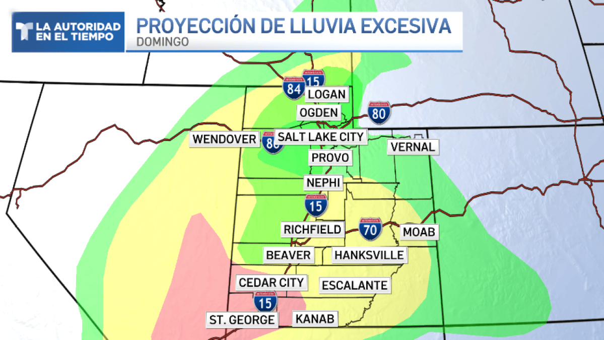
UTZ101>112-114-115-120345-
/O.CON.KSLC.FA.A.0012.000000T0000Z-261013T0000Z/
/00000.0.ER.000000T0000Z.000000T0000Z.000000T0000Z.OO/
Great Salt Lake Desert and Mountains-Tooele and Rush Valleys-
Eastern Box Elder County-Northern Wasatch Front-Salt Lake Valley-
Utah Valley-Cache Valley/Utah Portion-Wasatch Back-Bear Lake and
Bear River Valley-Wasatch Mountains I-80 North-Wasatch Mountains
South of I-80-Western Uinta Mountains-Western Uinta Basin-Western
Millard and Juab Counties-
Including the following locations - Garden City, Mantua, Alta,
Vernon, Park City, Lehi, Brigham City, Moon Lake, Park Valley, Mirror
Lake Highway, Bountiful, Heber City, Brighton, Delta, Roosevelt,
Duchesne, Woodruff, Logan, Randolph, Wendover, Payson, Tooele, Provo,
Grantsville, Salt Lake City, Smithfield, West Jordan, Snowville,
Logan Summit, Huntsville, Ogden, Sandy, Little Sahara, and Dugway
642 AM MDT Sun Oct 11 2026
...FLOOD WATCH REMAINS IN EFFECT THROUGH MONDAY AFTERNOON...
* WHAT...Flooding caused by excessive rainfall continues to be
possible.
* WHERE...A portion of Utah, including the following areas, Western
Millard and Juab Counties, Bear Lake and Bear River Valley, Cache
Valley/Utah Portion, Eastern Box Elder County, Great Salt Lake
Desert and Mountains, Northern Wasatch Front, Salt Lake Valley,
Tooele and Rush Valleys, Utah Valley, Wasatch Back, Wasatch
Mountains I-80 North, Wasatch Mountains South of I-80, Western
Uinta Basin and Western Uinta Mountains. This includes recent burn
scars such as Rocky Canyon.
* WHEN...Through Monday afternoon.
* IMPACTS...Excessive runoff may result in flooding of rivers,
creeks, streams, and recent burn scars. Flooding may occur in poor
drainage and urban areas. Extensive street flooding and flooding of
creeks and rivers are possible.
* ADDITIONAL DETAILS...
- Moisture associated with the remnants of Tropical Storm Rachel
will continue to spread into northern Utah producing a prolonged
rainfall event. In particular, moisture interacting with a
frontal boundary across far northern Utah may yield locally
heavier rainfall totals compared to other locations. As a result,
areal flooding is possible across northern Utah.
- http://www.weather.gov/safety/flood
PRECAUTIONARY/PREPAREDNESS ACTIONS...
You should monitor later forecasts and be alert for possible Flood
Warnings. Those living in areas prone to flooding should be prepared
to take action should flooding develop.
&&
$$
LCFlood Watch
National Weather Service Salt Lake City UT
642 AM MDT Sun Oct 11 2026
UTZ113-116>131-120345-
/O.CON.KSLC.FA.A.0012.000000T0000Z-261013T0000Z/
/00000.0.ER.000000T0000Z.000000T0000Z.000000T0000Z.OO/
Wasatch Plateau/Book Cliffs-Eastern Juab/Millard Counties-Central
Mountains-Sanpete Valley-Sevier Valley-Castle Country-San Rafael
Swell-Southwest Utah-Lower Washington County-Zion National Park-
Southern Mountains-Upper Sevier River Valleys-Bryce Canyon
Country-South Central Utah-Capitol Reef National Park and
Vicinity-Western Canyonlands-Glen Canyon Recreation Area/Lake
Powell-
Including the following locations - Emery, Milford, Green River,
Cedar City, Fish Lake, Castle Dale, Koosharem, Springdale, Goblin
Valley, Hanksville, Fillmore, Ivins, Escalante, Beaver, Nephi,
Bullfrog, Salina, Alton, Big Water, Torrey, Richfield, Scipio,
Circleville, Bryce Canyon City, Loa, Kanab, Scofield, Indian Canyon,
Panguitch, Ephraim, Manti, Cove Fort, Joes Valley, St George, Price,
Mt Pleasant, Brian Head, and Hurricane
642 AM MDT Sun Oct 11 2026
...FLOOD WATCH REMAINS IN EFFECT THROUGH MONDAY AFTERNOON...
* WHAT...Flash flooding caused by excessive rainfall continues to be
possible.
* WHERE...A portion of Utah, including the following areas, Castle
Country, Central Mountains, Eastern Juab/Millard Counties, San
Rafael Swell, Sanpete Valley, Sevier Valley, Wasatch Plateau/Book
Cliffs, Bryce Canyon Country, Capitol Reef National Park and
Vicinity, Glen Canyon Recreation Area/Lake Powell, South Central
Utah, Southern Mountains, Upper Sevier River Valleys, Western
Canyonlands, Lower Washington County, Southwest Utah and Zion
National Park. This also includes recent burn scars such as
Forsyth, Cottonwood, Silver King, France Canyon, and Monroe Canyon.
* WHEN...Through Monday afternoon.
* IMPACTS...Excessive runoff may result in flooding of rivers,
creeks, streams, dry washes, slot canyons, and other low-lying and
flood-prone locations such as slickrock areas and recent burn
scars. Creeks and streams may rise out of their banks. Flooding may
occur in poor drainage and urban areas.
* ADDITIONAL DETAILS...
- Anomalously high moisture from the remnants of Tropical Storm
Rachel will continue to impact the region. While this is expected
to be a long duration rainfall event, scattered instances of
heavier rainfall rates are expected with stronger storms yielding
flash flooding concerns given saturated soils and prior burn
scars.
- http://www.weather.gov/safety/flood
PRECAUTIONARY/PREPAREDNESS ACTIONS...
You should monitor later forecasts and be prepared to take action
should Flash Flood Warnings be issued.
&&
$$Flood Watch
National Weather Service Pocatello ID
535 AM MDT Sun Oct 11 2026
IDZ051>067-073-075-112100-
/O.CON.KPIH.FA.A.0003.000000T0000Z-261013T0000Z/
/00000.0.ER.000000T0000Z.000000T0000Z.000000T0000Z.OO/
Shoshone/Lava Beds-Arco/Mud Lake Desert-Upper Snake River Plain-
Lower Snake River Plain-Eastern Magic Valley-Southern
Hills/Albion Mountains-Raft River Region-Marsh and Arbon
Highlands-Franklin/Eastern Oneida Region-Bear River Range-Bear
Lake Valley-Blackfoot Mountains-Caribou Range-Big Hole Mountains-
Teton Valley-Centennial Mountains - Island Park-Beaverhead -
Lemhi Highlands-Sun Valley Region-Wood River Foothills-
Including the cities of Craters of the Moon NM, Rexburg, Heyburn,
McCammon, Ashton, Galena, Shelley, Holbrook, Preston, Oakley, Hailey,
Blackfoot, Rupert, Emigration Summit, Henry, Lava Hot Springs, Small,
Carey, Burley, Sun Valley, Richfield, INL,
Thatcher, Wayan, Malad, Albion, Driggs, St. Charles, Swan Valley,
Edie School, Fort Hall, Picabo, Inkom, Shoshone, Almo, St.
Anthony, Tetonia, Idaho Falls, Pocatello, Kilgore, Malta, Downey,
Dubois, Montpelier, Grace, Bellevue, Island Park, Bone, Victor,
Georgetown, American Falls, Soda Springs, Rockland, Spencer, Ketchum,
and Mud Lake
535 AM MDT Sun Oct 11 2026
...FLOOD WATCH REMAINS IN EFFECT THROUGH MONDAY AFTERNOON...
* WHAT...Flooding caused by excessive rainfall is possible.
Additional amounts of 0.75 to 1.5 inches are expected with some
places pushing 2 inches.
* WHERE...Portions of central, eastern, south central, and southeast
Idaho, including the following areas, in central Idaho, Sun Valley
Region and Wood River Foothills. In eastern Idaho, Beaverhead -
Lemhi Highlands, Big Hole Mountains, Centennial Mountains - Island
Park and Teton Valley. In south central Idaho, Eastern Magic Valley
and Shoshone/Lava Beds. In southeast Idaho, Arco/Mud Lake Desert,
Bear Lake Valley, Bear River Range, Blackfoot Mountains, Caribou
Range, Franklin/Eastern Oneida Region, Lower Snake River Plain,
Marsh and Arbon Highlands, Raft River Region, Southern Hills/Albion
Mountains and Upper Snake River Plain.
* WHEN...Through Monday afternoon.
* IMPACTS...Excessive runoff may result in flooding of rivers,
creeks, streams, and other low-lying and flood-prone locations.
* ADDITIONAL DETAILS...
- A prolonged period of rainfall is expected across eastern Idaho
throughout the weekend which could lead to some flooding across
parts of the advised area. An upper low moving into the Pacific
Northwest will combine with tropical moisture from Tropical
Cyclone Rachel to usher in a cooler, wetter weather pattern
across eastern Idaho.
- http://www.weather.gov/safety/flood
PRECAUTIONARY/PREPAREDNESS ACTIONS...
You should monitor later forecasts and be alert for possible Flood
Warnings. Those living in areas prone to flooding should be prepared
to take action should flooding develop.
&&
$$
JKeyes
Freeze WatchURGENT - WEATHER MESSAGE
National Weather Service Las Vegas NV
208 PM PDT Sun Oct 11 2026
CAZ582-121200-
/O.CON.KVEF.FZ.A.0001.261013T0700Z-261013T1700Z/
Owens Valley North-
Including the cities of Bishop, Lone Pine, and Independence
208 PM PDT Sun Oct 11 2026
...FREEZE WATCH REMAINS IN EFFECT FROM LATE MONDAY NIGHT THROUGH
TUESDAY MORNING...
* WHAT...Sub-freezing temperatures as low as 30 possible.
* WHERE...Northern Owens Valley.
* WHEN...From late Monday night through Tuesday morning.
* IMPACTS...Frost and freeze conditions could kill crops, other
sensitive vegetation and possibly damage unprotected outdoor
plumbing.
PRECAUTIONARY/PREPAREDNESS ACTIONS...
Take steps now to protect tender plants from the cold.
To prevent water pipes from freezing; wrap or drain or allow them to
drip slowly.
&&
$$URGENT - WEATHER MESSAGE
National Weather Service Las Vegas NV
208 PM PDT Sun Oct 11 2026
NVZ014-121200-
/O.CON.KVEF.WI.Y.0018.000000T0000Z-261012T1200Z/
/O.CON.KVEF.FZ.A.0001.261013T0700Z-261013T1700Z/
Esmeralda and Central Nye County-
Including the cities of Dyer, Beatty, Silver Peak, and Goldfield
208 PM PDT Sun Oct 11 2026
...WIND ADVISORY REMAINS IN EFFECT UNTIL 5 AM PDT MONDAY...
...FREEZE WATCH REMAINS IN EFFECT FROM LATE MONDAY NIGHT THROUGH
TUESDAY MORNING...
* WHAT...For the Wind Advisory, south winds 15 to 25 mph with gusts
up to 45 mph. For the Freeze Watch, sub-freezing temperatures as
low as 30 possible.
* WHERE...Esmeralda and Central Nye County.
* WHEN...For the Wind Advisory, until 5 AM PDT Monday. For the Freeze
Watch, from late Monday night through Tuesday morning.
* IMPACTS...Gusty winds will blow around unsecured objects. Tree
limbs could be blown down and a few power outages may result. Frost
and freeze conditions could kill crops, other sensitive vegetation
and possibly damage unprotected outdoor plumbing.
PRECAUTIONARY/PREPAREDNESS ACTIONS...
Winds this strong can make driving difficult, especially for high
profile vehicles. Use extra caution.
Secure outdoor objects.
Take steps now to protect tender plants from the cold.
To prevent water pipes from freezing; wrap or drain or allow them to
drip slowly.
&&
$$
Special Weather StatementSpecial Weather Statement
National Weather Service Elko NV
607 PM PDT Sun Oct 11 2026
NVZ040-120130-
Northwestern Nye County NV-
607 PM PDT Sun Oct 11 2026
...A STRONG THUNDERSTORM WILL IMPACT NORTHWESTERN NYE COUNTY THROUGH
630 PM PDT...
At 607 PM PDT, Doppler radar was tracking a strong thunderstorm 21
miles west of Round Mountain, moving northeast at 30 mph.
HAZARD...Wind gusts up to 50 mph and half inch hail.
SOURCE...Radar indicated.
IMPACT...Heavy rainfall along with gusty winds could knock down tree
limbs and blow around unsecured objects. Minor hail damage
to vegetation is possible.
Locations impacted include...
Arc Dome.
PRECAUTIONARY/PREPAREDNESS ACTIONS...
If outdoors, consider seeking shelter inside a building.
Torrential rainfall is also occurring with this storm and may lead to
localized flooding. Do not drive your vehicle through flooded
roadways.
Frequent cloud to ground lightning is occurring with this storm.
Lightning can strike 10 miles away from a thunderstorm. Seek a safe
shelter inside a building or vehicle.
Persons in campgrounds should consider seeking sturdy shelter until
this storm passes.
&&
LAT...LON 3849 11751 3859 11765 3894 11747 3876 11714
TIME...MOT...LOC 0107Z 211DEG 25KT 3869 11746
MAX HAIL SIZE...0.50 IN
MAX WIND GUST...50 MPH
$$
98