Utah's snow forecast favors a substantial reload from Sunday night into Monday, according to a October 30 report. Alta currently leads the outlook for remaining accumulation, with significant snowfall expected across several mountain resorts.
Saturday is expected to bring a relative lull in the ongoing unsettled pattern, with lingering showers favoring the highest terrain. Snow levels near 9,500-10,000 feet will keep lower elevations vulnerable to rain or a mix, while snow at higher elevations remains wet and dense. Brian Head continues to pick up occasional snow rather than starting a new storm. Moisture is expected to increase late Saturday night into Sunday, accompanied by stronger southerly winds with gusts around 40-50 mph at Brian Head affecting exposed terrain.
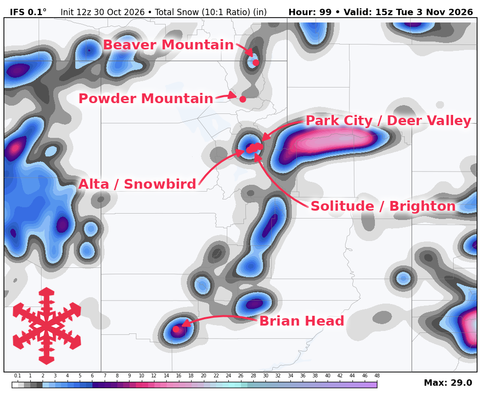
Sunday night into Monday remains the best opportunity for colder, more widespread mountain accumulation. An atmospheric river is expected to supply moisture ahead of a strong cold front, with snow levels initially near or above 9,000 feet before falling toward 6,500-7,000 feet by early Monday across northern Utah. Northwest flow behind the front favors the upper Cottonwoods, where temperatures falling into the 20s should produce moderately lighter snow over the initial dense layer. Alta could receive 17-23 inches, while Brian Head remains a beneficiary with 13-19 inches.
None of the resorts covered are open for skiing, providing a base-building opportunity ahead of Brian Head's planned Friday, November 6 opening. Snow is expected to taper Monday into early Tuesday, followed by quieter weather and lighter winds. While cold early-morning temperatures favor preservation, milder Tuesday afternoons may promote settling and melting at lower elevations. A mostly stable break extends into Wednesday, though some guidance allows for a weak disturbance around midweek.
Snowfall totals for the period of Friday, Oct. 30 through Tuesday, Nov. 03 include Alta at 17-23 inches, Brian Head at 13-19 inches, and Brighton at 12-18 inches. Snowbird is forecasted for 12-17 inches, Solitude for 7-11 inches, Park City for 5-7 inches, Powder Mountain for 3-5 inches, Deer Valley for 3-4 inches, and Beaver Mountain for 2-3 inches.
Later next week brings uneven chances for modest mountain refreshes. Farther into November, precipitation opportunities may increase, though a warmer-than-normal tendency keeps snow levels relevant and confidence in another major snowstorm low.