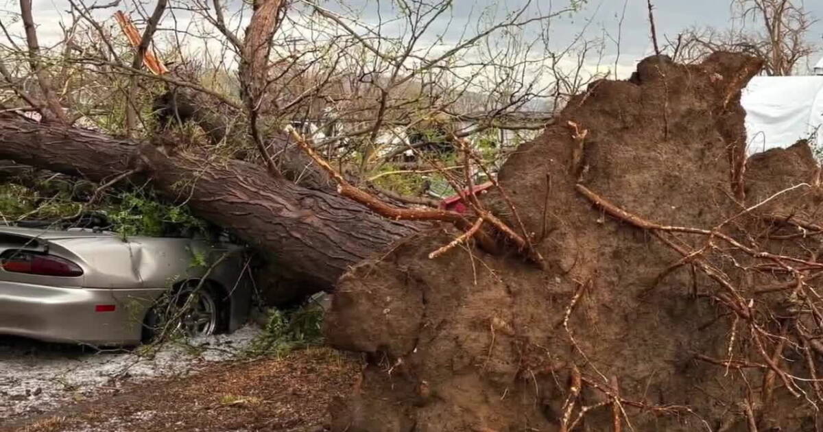
A destructive thunderstorm produced straight-line winds estimated at 100 mph in Lynndyl on Aug. 29, 2026, overturning 34 empty railroad cars and causing widespread damage to homes and agriculture, according to a National Weather Service damage survey.
Destructive Wind and Hail Patterns
The National Weather Service Salt Lake City conducted a damage assessment following the Aug. 29, 2026, event, which they characterized as a significant microburst. The storm began near the northwest side of Lynndyl at approximately 4:25 PM MDT and concluded near Leamington at 5:00 PM MDT, according to a public information statement from the agency.
Investigators found a swath of destruction stretching approximately 17.42 miles long and 2 miles wide. The storm's impact was most visible in the town of Lynndyl, where the wind-driven hail and high winds caused immense damage to the west-facing sides of homes, including broken windows, damaged siding, and damaged roofs. In some instances, the wind stripped shingles from the roofs of multiple residences and ripped a structural awning from a house, depositing it in a backyard.
Impact on Infrastructure and Agriculture
The storm's intensity was evidenced by the displacement of heavy objects and the destruction of local infrastructure. The National Weather Service reported that 34 empty railroad cars were blown over toward the east-southeast near the northwest side of town. Additionally, the wind destroyed a metal carport and a small pole barn, leaving them flattened in place.
In addition to structural damage, the storm caused significant impacts to local vegetation and agriculture. A corn field located south and east of Lynndyl, which was nearing harvest readiness, was shredded by wind-driven hail. The stalks were reported as being snapped and bent over near the ground, laid flat from a west-to-east orientation.
Further southwest of Lynndyl, the storm stripped vegetation from sagebrush along a 2-mile wide swath where the storm crossed route 174. The National Weather Service noted that while exact hail size measurements were not available, visual evidence showed hail stones as large as golf balls drifting against the west sides of buildings.
Microburst Characteristics and Casualties
The National Weather Service attributed the extreme wind speeds to a microburst event, characterized by downward and outward divergent wind patterns. While the storm caused significant property damage, the agency reported that the event resulted in one injury and zero fatalities.
Specific wind indicators included the uprooting of numerous hardwood trees and the snapping of several others. The storm also knocked down several free-standing power poles. The survey noted a divergent pattern in the wind field on the north end of town, where trees north of Railroad Ave and US-6 were downed toward the northeast, while trees further south were downed toward the east and east-southeast.
Regional Storm Activity
The Storm Prediction Center documented various storm reports for the period between Aug. 29 and Aug. 30, 2026. In addition to the major event in Lynndyl, the center recorded a variety of hail and wind reports across the region.
In Dugway, a report noted receiving hail photos from Dugway English Village immediately after the storm core passed, describing classic hail shapes up to 1 inch in size. In Leamington, social media reports indicated half-dollar sized hail. The Storm Prediction Center also recorded wind speeds of 64 mph in Clive and 64 mph in Dugway, as well as 66 mph in Atlantic City, Wyoming, and 71 mph in Rawlins, Wyoming.
County Oversight
The Millard County Sheriff's Office serves the community through law enforcement and crime prevention efforts. Interim Sheriff Steve O'Camb stated that the office is dedicated to keeping the community informed and providing easy access to sheriff's office services as they face evolving technological and community challenges.
Weather Outlook
The National Weather Service continues to monitor weather patterns in the region. In August 2026, the agency noted that monsoon moisture in the region brought daily threats of showers and thunderstorms, with some storms capable of producing heavy rain, frequent lightning, and gusty winds.
Assessment Status
The National Weather Service's assessment of the Aug. 29, 2026, event remains preliminary and is subject to change pending a final review for official publication in NWS Storm Data.